Creek Fire Continues to Burn Uncontrolled
Auberry, Big Creek, China Peak, Huntington Lake, Shaver Lake, Tollhouse, All Under Siege
A fire that started in the Camp Sierra area on Friday afternoon, Sept. 4, has now grown to over 201,000 acres, burning in three California counties. Click here to see an interactive map on Shaver Lake and Auberry fire damaged structures.
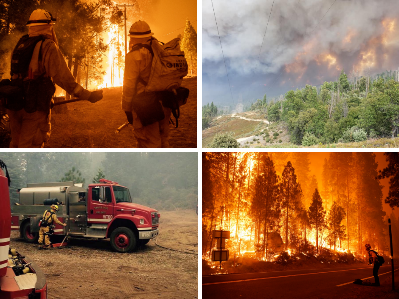
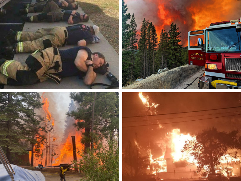
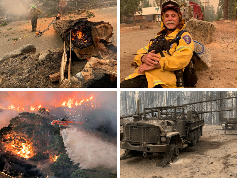
Over a 1,600 firefighters along with their engines, water tenders, bulldozers, air attack crews and logistics personnel are waging war against this inferno. There is just 8% containment. It has burnt for the past nine days.
It is being estimated that 371 structures have been destroyed. It is now burning towards North Fork and Bass Lake in Madera County as well as threatening wild land and property in Mariposa County. In Fresno County is continues to flare up at Auberry, Huntington Lake, Shaver Lake and Tollhouse. Winds have erratic and air support has been unavailable to assist the firefighting efforts.
Shaver Lake area resorts and other businesses were shocked over Labor Day Weekend, a time that they usually have a financial lift at the end of the summer season.
A team of disaster management specialists are trying to get into the area ravaged by flames to see the exact nature of the damage that has taken place. This is an event that many had dreaded over several years.
Once the fire reached Cressmans, it virtually took only minutes to turn this historic landmark into a pile of smoldering ashes. The fire jumped Highway 168, torn down the hill through bark beetle infested trees that burned furiously. Several homes were lost in the area.
Not only did the Cressmans' owners lose the business, their home was also destroyed not far away in the Pine Ridge region. They have vowed to rebuild and expressed thanks to all those that have sent condolences and good wishes.
Historic Cressman's General Store Destroyed Tuesday Night
The extremely popular fuel station and general store at Cressmans, at the top of the four lane on Highway 168, is being mourned by local residents as well as thousands of tourists that stop and take advantage of all the wonderful items the staff offers. "
Once the fire reached Cressmans, it virtually took only minutes to turn this historic landmark into a pile of smoldering ashes. The fire jumped Highway 168, torn down the hill through bark beetle infested trees that burned furiously. Several homes were lost in the area.
Not only did the Cressmans' owners lose the business, their home was also destroyed not far away in the Pine Ridge region. They have vowed to rebuild and expressed thanks to all those that have sent condolences and good wishes.
The Creek Fire started on Friday, Sept 4 and exploded overnight.
Local Fire Crews Along With CalFire and US Forest Service Battle Blaze
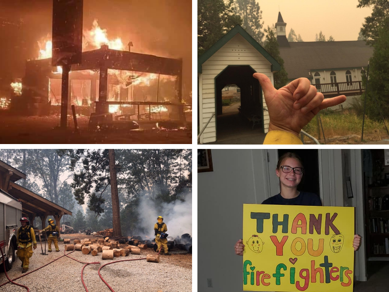
The community comes together to fight fire.
Naturally the local volunteer fire department from Auberry, Bald Mountain, Big Creek, Huntington Lake, Pine Ridge and Shaver Lake are involved in working to stop this fire. They have been joined by CalFire and the US Forest Service.
Strike teams from Clovis, Fresno, Sanger and other local communities have joined the effort as well as fire crews from as far away as Torrance and Manhattan Beach in Southern California.
Law enforcement help is coming from the California Highway Patrol, Fresno County Sheriff, Clovis and Fresno police as well as officers from as far away as Coalinga.
In Fresno County, the Incident Command Center has been set up at Sierra High School in Tollhouse. Hundreds of local civilians have been gathering water, Gatorade, snacks, socks, batteries and other items that may be needed by the crews on the line. Several evacuation centers have been set up to accommodate those that have been displaced by this horrible event.
It is suggested that those wanting to make donations to help with this effort to contact the American Red Cross. They take cash donations
and provide whatever is needed by those seeking refuge. The Clovis Rodeo Grounds and Fresno Fair Grounds are among the locations where folks with large animals can take them to be safe during this event.
Some hikers, fishermen and others were stranded in the backcountry near Lake Edison, Mono Lake, Florence Lake and Muir Trail Ranch. The National Guard used choppers to evacuate these individuals over the past couple of days. On Saturday, over 200 people were rescued at Mammoth Pools by the National Guard when they were overtaken by this fire.
Jim Clement and his crew at Vermilion Valley Resort at Lake Edison have been singled out by several people that were displaced at that facility. All said that these folks stepped up big to make sure they had drinks and food to eat.
There is concern as to how China Peak Ski Resort fared during this event. Reports state that their employee housing was destroyed on Tuesday. No word has come in regarding the Main Lodge, Hotel, Vehicle Maintenance and other buildings at the site.
Resource Center for Rebuilding the Region and Moving Forward
Here's how you can help people impacted by massive wildfire, first responders.
Shaver Lake/Huntington Lake Fire Facebook
Creek Fire Evacuation Map
Fresno county public health
Red Cross Disaster Relief
Evacuation Centers
Clovis North High School, 2770 East International Ave. Clovis, CA
Mariposa County Fairgrounds, 5007 Fairgrounds Rd, Mariposa, CA 95338
Note:The Red Cross has moved its Oakhurst evacuation center to Mariposa due to the continued growth of the Creek Fire.
RELATED: How to prepare for a wildfire evacuation
Animal Evacuation Centers Fresno County:
Small animals: Clovis North 2770 East International Ave. Fresno, CA
Livestock: Fresno Fairgrounds, 1121 S Chance Ave, Fresno, CA 93702
(FULL) Clovis Rodeo Grounds 748 Rodeo Drive Clovis, CA
Note: The Clovis Rodeo Grounds have reached capacity. People can bring livestock and larger animals to the Fresno Fairgrounds.
Madera County:
Small animals: Oakhurst Community Center 39800 Road 425B Oakhurst, CA
Horses only: Coarsegold Rodeo Grounds 44777 Rodeo Grounds Lane, Coarsegold, CA
SEE ALSO: Creek Fire: Where to bring large animals, livestock displaced by wildfire
Evacuation AlertsYou can register for evacuation alerts on the following sites.
Fresno County: https://t.co/Otack9NyKc?amp=1
Madera County: mcalert.org
Mariposa County: msoalert.com
Missing PersonsFor missing persons, contact the Fresno County Sheriff's Office at 559-600-3111 or the Madera County Sheriff's Office at 559-658-2555.
Track the Wildfire Smoke The Creek Fire and dozens of other wildfires burning in California has caused a heavy layer of smoke to settle in the air. The National Oceanic and Atmospheric Administration is tracking how the smoke is moving across the state and West Coast.
Click here to track the wildfire smoke in your area.
Track Flight RoutesSee how the wildfire smoke is impacting air travel in California. Click here to track current flight routes.
United States Postal ServiceIf your post office was forced to close due to the Creek Fire, the U.S. Postal Service has released information on how to pick up your mail. Click here for more.
Shaver Lake/Huntington Lake Fire Facebook
Creek Fire Evacuation Map
Fresno county public health
Red Cross Disaster Relief
Evacuation Centers
Note:The Red Cross has moved its Oakhurst evacuation center to Mariposa due to the continued growth of the Creek Fire.
RELATED: How to prepare for a wildfire evacuation
Animal Evacuation Centers Fresno County:
Madera County:
SEE ALSO: Creek Fire: Where to bring large animals, livestock displaced by wildfire
Evacuation AlertsYou can register for evacuation alerts on the following sites.
Missing PersonsFor missing persons, contact the Fresno County Sheriff's Office at 559-600-3111 or the Madera County Sheriff's Office at 559-658-2555.
Track the Wildfire Smoke The Creek Fire and dozens of other wildfires burning in California has caused a heavy layer of smoke to settle in the air. The National Oceanic and Atmospheric Administration is tracking how the smoke is moving across the state and West Coast.
Click here to track the wildfire smoke in your area.
Track Flight RoutesSee how the wildfire smoke is impacting air travel in California. Click here to track current flight routes.
United States Postal ServiceIf your post office was forced to close due to the Creek Fire, the U.S. Postal Service has released information on how to pick up your mail. Click here for more.
Crews from surrounding communities help out.
Random images of the Creek Fire.
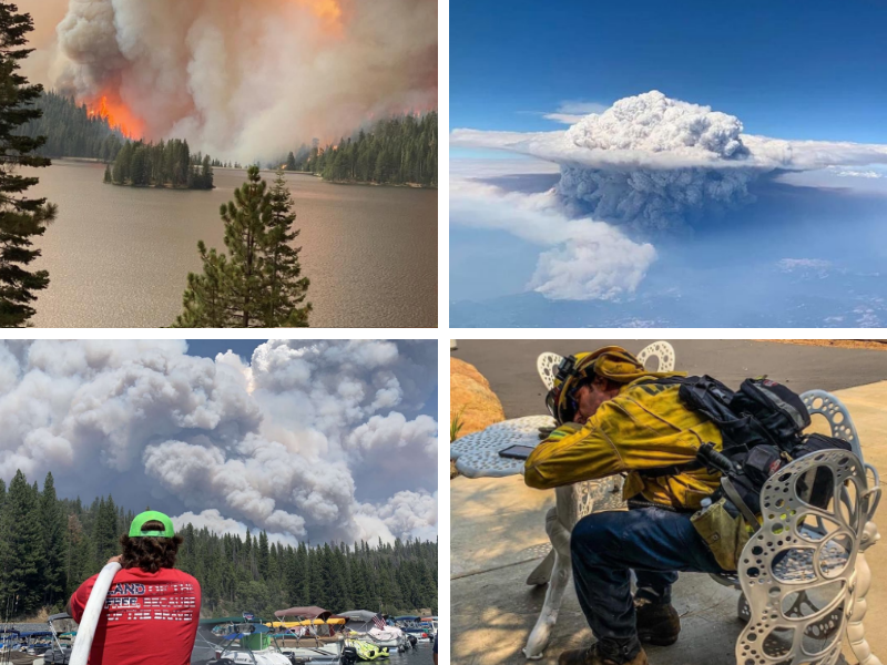
Amazing visuals from the Creek Fire.
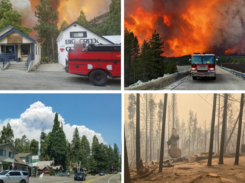
Five days of a firestorm in the mountains.